SW La. expected to feel some ‘indirect impacts’ from Tropical Storm Alberto
Published 4:00 pm Wednesday, June 19, 2024
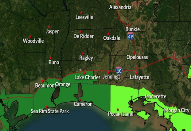
- Coastal flooding will occur as the large wind field and fetch will help pile water along the coast through Thursday. (National Weather Service Lake Charles)
Tropical Storm Alberto formed on Wednesday in the southwestern Gulf of Mexico, the first named storm of the hurricane season.
Alberto, which is bringing strong winds, heavy rainfall and some flooding along the coasts of Texas and Mexico, is expected to make landfall in northern Mexico Thursday.
The National Hurricane Center said Wednesday afternoon that Alberto was located about 170 miles east of Tampico, Mexico, and about 305 miles south-southeast of Brownsville, Texas, with maximum sustained winds of 40 mph. The storm is moving west-southwest at 9 miles per hour.
Trending
Joe Rua, a meteorolgist with the National Weather Service’s Lake Charles office, said Southwest Louisiana will see some indirect impacts, mainly coastal flood issues and hazardous seas.
“The large wind field and fetch of easterly winds will continue to pile water up along the coast, with the most significant coastal flooding along the southeast Texas and Southwest Louisiana coast that will likely extend up into the north end of Sabine and Calcasieu Lakes,” Rua said. “The coastal flood hazards will extend through 1 p.m. Thursday.”
He said hazardous seas will continue into Thursday for all the coastal waters with seas from 5 to 13 feet.
Rua said there is the potential for another broad low to form in the southwest Gulf of Mexico over the weekend that has a 30 percent chance of Tropical Cyclone formation through the next 7 days.
“However, at this time no impacts are expected from this system as a strong area of high pressure is forecast to build across the northern Gulf Coast,” he said.
Michael Brennan, director of the National Oceanic and Atmospheric Administration’s National Hurricane Center, said the center of Alberto was expected to reach the northeastern coast of Mexico south of the mouth of the Rio Grande by early Thursday.
Brennan said that winds could get up to 45 mph to 50 mph before the storm makes landfall.
As much as 5 inches to 10 inches of rain was expected in some areas along the Texas coast, with even higher isolated totals possible, Brennan said. He said some higher locations in Mexico could see as much as 20 inches of rain, which could result in mudslides and flash flooding, especially in the states of Tamaulipas, Coahuila and Nuevo Leon.
Tropical storm warnings were in effect from the Texas coast at San Luis Pass southward to the mouth of the Rio Grande and from the northeastern coast of Mexico south of the mouth of the Rio Grande to Tecolutla.
“Rapid weakening is expected once the center moves inland, and Alberto is likely to dissipate over Mexico” Thursday, the center said.
NOAA predicts the hurricane season that began June 1 and runs through Nov. 30 is likely to be well above average, with between 17 and 25 named storms. The forecast calls for as many as 13 hurricanes and four major hurricanes.
•
The Associated Press contributed to this story.
