Milton gains strength at rate rarely seen
Published 2:05 pm Monday, October 7, 2024
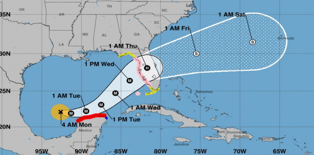
Mandatory evacuations have been issued in Florida after Hurricane Milton rapidly intensified into a major hurricane in the southern Gulf of Mexico Monday morning.
Hurricane watches have been issued for over 6 million people in west-central Florida, including the Tampa area. Tropical storm watches are also in effect for much of Florida’s Gulf Coast — including the Big Bend area, which was struck by Hurricane Helene less than two weeks ago.
After being upgraded from a tropical storm on Sunday, it underwent what National Hurricane Director Michael Brennan called an “explosive” rate of intensification.
Trending
The NHC said it has seen such rapid strengthening in a storm system only twice before: Wilma in 2005 and Felix in 2007.
At 8 a.m. Monday morning, Milton was a Category 3 with winds of 125 mph. By 9 a.m. Hurricane Hunters flying through the heart of the storm determined it was a “powerhouse” Category 4 with winds of 150 mph. Just two hours, it was deemed a Category 5 — the strongest of the classifications — on Monday morning, with maximum sustained winds of 175 mph .
Parts of the Florida Peninsula and Keys could see 5 to 10 inches of rain through Wednesday night, with localized totals of up to 15 inches in some areas, according to the NHC.
There is also a growing risk of life-threatening storm surge and damaging winds for parts of Florida’s west coast beginning late Tuesday or early Wednesday. Forecasters say it could raise water levels to as high as 8 to 12 feet in coastal areas of Florida, including Tampa Bay.
National Weather Service’s Lake Charles Office Lead Meteorologist Joe Rua said no tropical impacts are expected for central or Southwest Louisiana — although tides along the coast will be about a foot above normal through mid-week.
“Take care, everyone, and send prayers and good wishes to those in the Florida Peninsula that may be dealing with impacts from a major hurricane on Wednesday,” Rua said.
Rua said a cold front moving across Southwest Louisiana Monday night will keep steering Milton toward Florida.
This will help reinforce the dry conditions in place in the region while bringing cooler temperatures for the next few days, he said.
Day temperatures are expected to drop into the low-to-mid 80s through Thursday with minimum relative humidity. Temperatures are expected to drop into the low 50s.